Spatial-Social-Economic Urban Analytics
KEY INFORMATION
TECHNOLOGY OVERVIEW
Many existing smart city solutions only show the impact of urban development, but few show the impact that urbanisation imposes on daily activities and long-term outcomes such as population obesity and job availability/accessibility. In short, such solutions show the activities e.g. large crowds are visiting the neighbourhood park, that are happening in real-time (what), the location (where), and the time that they occur (when), but do not have the ability to include data that makes it possible to explain the reason for such activities (why). In order to bring about any intervention or identify missed opportunities, understanding the reason behind such activity is vital.
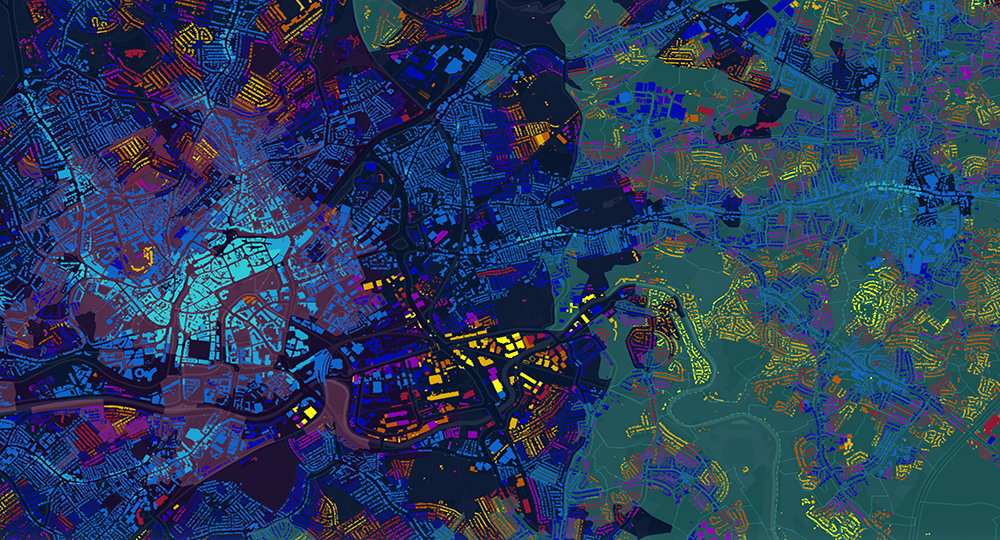
This technology utilises data on city infrastructure systems to help users understand how and where the built environment creates a set of physical constraints that influence what planned and unplanned activities are possible, and in turn how this influences long term outcomes including health and climate change. This technology imports, translates and combines datasets into spatialised models which are used to generate analytics outputs. These outputs include a comprehensive explanation of the way streets, pedestrian networks, public transport and land use interact with each other. In this manner, socio-economic and/or demographic datasets can be linked, enabling people and places to be combined in a single analytical model.
TECHNOLOGY FEATURES & SPECIFICATIONS
- Multiple software algorithms import, spatialise and translate standard format data including GIS, GeoJSON, JSON, CSV in to structural models
- Structural models can be analysed and queried in a variety of ways, from three-dimensional environemnts (3D) to POSTGRES database
- Model analysis can be created of large geographical areas (e.g. a large city) providing analysis results to the granularity of an individual building. Results can be assigned to, and aggregated up to multiple choropleth boundaries.
- Analysis supports simultaneous multiple-scale, multiple modalities and various costs of movement such as time, distance and financial
- Results can be integrated within other software models and visualised in standard GIS software or bespoke web-app interfaces which can be easily communicated to or understood by non-expert users
POTENTIAL APPLICATIONS
This technology is able to explain where, and why people are more likely to walk, cycle, take public or private transport, where footfall will be distributed and whether people can access the services they need (and the quality and capacity of the services they can get to). It shows how all city infrastructure systems combine from the point of view of a person to make cities walkable or car dependent. Additionally, it can plan the most efficient routes to connect multiple points in a city. It has been applied to design and planning industry but has the potential for other application areas:
Healthcare preventative strategies (population level and individual level):
- Individuals can be provided with tailored, preventative exercise or socially prescribed recommendations to individuals based on their age group, condition and living environment, e.g. make recommedendations on how often and where to exercise, or where they could congregate to interact with specific group activities
- At a population level, this solution can function as a service planning and delivery tool by linking places of risk with high-risk community groups in order to prioritise and plan improvements, e.g. enhancement of elderly care amenities
Logistics, last-mile deliveries:
- Locate physical services/collection points/hubs by understanding which locations in a city provide optimal access to a target population using active/clean modes of transportation, e.g. if a new collection point at a given location, would it have access to the customers of a target age and target income, within walking distance
Unique Value Proposition
This technology has been used to support public and private sectors. It helps decision making in investment, planning, and behaviour change interventions. It also helps property owners to identify whether they are making full use of their assests, and supports private sector companies who offer place-based services, such as urban mobility, delivery of goods/services or logistics which require the linkage of people-to-places.
Potential benefits include, but are not limited to:
- Increased likelihood of a service/business/intervention being correctly targeted to a specific location and exposed to its target market, reducing the risk of failure
- Contribute to long-term Environmental, Social and Governance (ESG) goals, most notably in terms of health and climate change, which in turn, improves individual quality of life and reduces healthcare treatment costs
- Enables scenario-testing of schemes and decisions, and evaluate for cross-sectorial integration, e.g. healthcare, transport, urban planning